| Nepal - Three Peaks and Three Passes Day by Day |
| Nepal - Three Peaks and Three Passes Summary |
| Notable Ascents |
| Kapsale (not summit) (4,300m) |
| Renjo La (5,360m) |
| Gokyo Ri (5,357m) |
| Cho La (5,420m) |
| Everest Base Camp (5,364m) |
| Kala Patthar (5,643m) |
| Kongma La (5,528m) |
| Chukhung Ri (5,546m) |
There are many treks in the Himalaya but the Three Peaks and Three passes trek seems to be one of the best, if not the best thought out treks of all.

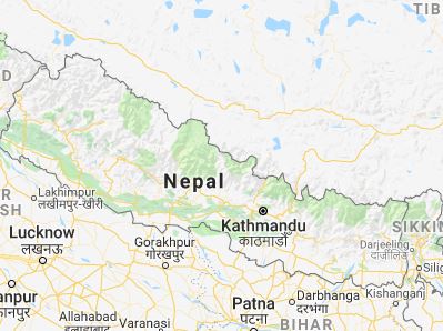
The three week trek starts in Kathmandu and travels in a clockwise direction flying first to Lukla, then onwards through Namche, Thame and the Renjo La pass (5,360m), then Gokyo Ri (5,357m) before heading out via the Cho La Pass (5,420m) to Lobuche and on to Everest Base Camp via Gorak Shep and an ascent of Kala Pattar (5,643m), returning and crossing the Kongma La (5,528m) to ascend Chukhung Ri (5,546m) and back via Dingboche and Tengboche to Namche Bazaar and onwards to Lukla again and finally back to Kathmandu.
Having used and been impressed with Jagged Globe I booked my trip with them. They don't have exclusive rights this tour though and in fact it is marked on the Nepalese Trekking map NE517 as the Three Peaks and Three Passes trek. It will be interesting to see how many other trekking teams are out there - I doubt we will have it to ourselves.
As usual, Jagged Globe organised a training and get-together weekend for those adventurers off to Nepal this year on various treks; some doing Annapurna, some on the Everest Base Camp trek and us.
Over the weekend I got to meet most of the others on the Three Peaks and Three Passes trip and a fine bunch they seemed. There are fourteen of us in total plus our British Guide.
Saturday we had the usual kit, altitude, illness discussions followed by a traditional Nepalese meal.

Sunday we were off to the Peak District for a walk up onto Kinder Scout via a new (for me) route. We started at the car park on the Snake Rd (A57) just past the Snake Inn, crossing the road and heading into the woods. Many years ago I organised a bivvy weekend which had this exact place as the overnight stop. Continuing through the woods we gained altitude, emerging onto a plain but following a reasonably good path, which it transpired was an old Drovers route between Sheffield and Manchester. Passing an old Inn which was in a very poor state, the incline sharpened with the main Kinder Scout ridge ahead of us. We took a very direct route up which I think caught one or two out as they came panting to the top. Lunch was declared!

From here we followed the edge around until a natural descent following a stream bought us back to the River Alsop which was then a short walk, bridge crossing and up to the car park via crossing the road and into another short wooded section where we came across the worst mess anyone had ever seen - there were bottles, cardboard, disused gas canister and general rubbish everywhere. We had seen a group of ill-equipped youths on the way up as we descended and I am sure there were unvoiced thoughts that they were responsible.
The weekend closed with a summary of the weekend and goodbyes to all on the various trips.
The final countdown now begins to the adventure and another tick in the bucket list.

Nepal is the most amazing country. The high Himalaya is just incredible and about as different from home as it is possible to get. The views are stunning, the people incredibly friendly and genuinely helpful. It is a deeply religeous country, mostly Buddhist and all along the route there are Prayer wheels which, if turned, should be turned in a clockwise direction and passed with them on your right hand side. It gets quite addictive and I felt that I'd missed something if I failed to turn one. Apparently it is the equivalent of the Buddhist chant of 'Om Mani Padme Hum' which is also the repetitive carvings on the Mani Stones which are also seen along the route as stones placed or carved onto and into the rock. Prayer flags adorne high mountains, mountain passes, rocks, trees and just about everywhere. The meaning of the chant occupies volumes so I won't attempt to explain it here, in any case I'd probably get it wrong.
You might wonder why distances are seldom quoted nor easily available. In fact, in the country, destinations are quoted in time rather than miles or kilometres. The reason for this is that the distance is largely irrelevant since the altitude gain makes a nonsense of the distance. In a day, you might travel ten kilometres (six miles) but it will take nine hours as it crosses a 5,600m Pass. Ten kilometres at sea level on an easy trail could be done in less than three hours without any problems.
I won't detail my entire kit list here, it is too long and hopefully fairly obvious, but feel free to contact me via the 'Contact' page if you'd like the list. Here are a few thoughts and suggestions based on my three week trek;
Bring a change of clothes for use after showers and in the evening *only* which can then be kept clean and not worn during the day.
You can't have too many wet wipes and packs of tissues, although they can be purchased on the trail.
If you take tablets, pack them into a tupperware box to stop them getting crushed. On that note, anything that can be crushed should be packed into a tough box because the porters rope bags together and pull them *very* tight, compressing anything and everything inside (unlike the African porters who carry a single bag on their head).
Bring a Nasal Spray, you *will* get a cold.
When packing gear into your portered bag use lots of small waterproof stuff sacs rather than one big one, it is much easier to deal with.
Unless you seriously feel the cold, thermal leggings are a waste of space, but do bring one thick and one thin pair of trousers to cope with the differing temperatures.
On this trek Glacier glasses are not needed, but a pair of sunglasses are. Photochromic are ideal to cope with varying sunlight.
I found that I hardly used my large (300mm) lens nor my wide angle lens, the standard lens (18-105mm) was plenty. In any case, zooming in loses the scale and a wide angle lens can never really be wide enough. If you want super wide, use your phone on its panorama setting.
Have a method of attaching your camera to the outside of the rucsac, you will take a lot of photos!
A camera cleaning kit with plenty of tissues and a lens puffer is essential, it is very dry and dusty.
Make sure you have some duct tape, it solves a lot of problems. I wrapped a length around my talcum powder tube. A sharp knife is also useful for, amongst other things, cutting the duct tape.
The cost of electricity is high so mains adaptors are only useful if you don't mind paying up to Re500 per hour to charge your device. Much better to bring a power pack and Solar charger.
Finally, bring a notepad for a diary or just general notes and at least two pens - there will be a lot you won't remember and a lot that will blend into the same day/week/experience.
![]()
All photos and content Copyright © Mick Peakman 2018 -